Monday 21 March 2011

Ice Erosion Summary Report cont.

Human society can benefit from understanding landforms many times over, from reasons as pragmatic yet vitally necessary as farming in optimal conditions and knowing what crops will grow best in, to avoiding the dangers that they can pose such as the catastrophic collapse of many a glacial lake, to efforts in combating climate change by being proactive and working to reverse damage done instead of a quick fix, to appreciating these areas and their culture.

Understanding brings respect and proper care. Ice, while not the fastest or most common agent of erosion, is indubitably the most powerful out of other major causes such as water and wind. Ice can change the world. It can span continents, raze hillsides to soil and create the most majestic landforms seen anywhere on Earth. It can also change our lives, our ways of thinking, our attitudes and ideas; all of this from just understanding. Ice as an agent of erosion and inspirer of change truly is a force to be reckoned with.

Glacial Lakes

These lakes began life as large pools of glacial meltwater, and have been supplemented with rivers and rain since. At the end of the Last Glacial Maximum, glaciers began to recede in response to warming temperatures. Significant deposits of ice were left behind in the hollows of hills, which then melted and formed lakes. Glacial lakes are often accompanied by other signs of glacial activity, scoured valleys, deep striations in bedrock and other landforms which make up the surrounding landscape.


Glaciers grind rock that they flow over, turning them into sediments which form the bottom of the lake. On occasion, the result is so fine and silt-like that it is called glacial flour. When it becomes suspended within the water, it gives it a unique, sometimes milky colour along with a greenish tinge because of the algae which thrive in such mineral-rich water. Lakes formed by ice can be told apart from those formed by water. The banks of glacial lakes are irregular and jagged, reflecting how glaciers carve out a path through land, but lakes with origins in liquid water have smooth shores and are interconnected with rivers more often.

Where the glacier has been can be told from the sediments deposited within the lake, as glaciers are capable of transporting material far from where it originally lay. As sediment varies with location, it affects the water’s mineral content. Animal activity also leaves trace elements, which then go into forming layers of sediments at the bottom metres thick. Glacial lakes can be studied in this way by analysing these layers and their chemical composition; useful details may be found on dates and manner of formation, as well as recent changes and impacts on the lake.


Further reading on the dangers glacial lakes can be:
http://www.theuiaa.org/bursting_glacial_lakes_in_nepal.html

Sunday 20 March 2011

Benefits of Understanding Landforms 4

This century has marked a renewed interest in the impact humans are having on their environment. Much new knowledge has come to light, particularly the concept of climate change and global warming. This theory on future trends of the Earth’s climate has incensed much debate, particularly the possible outcomes and results this will have on the environment. They are quite bleak, predicting that biodiversity will shrink enormously, countless irreplaceable species will become extinct, weather patterns will become irrational and violent and that Earth will not recover from its countless ills for millions of years, if at all.


Such a chilling prospect has instigated newfound activity and effort in countries across the world. Public awareness has been raised, educational campaigns on what we can all do to help have been executed and research and innovation shown by our scientists. So where can ice-related landforms help?

A cause of many of the landforms explored here is the glacier. When exposed to warmer-than-usual conditions and disrupted weather patters, ice melts. For this reason glaciers have been studied as an indicator of past trends in the Earth’s climate history, garnered knowledge then used to make predictions about the future. Ice leaves behind clear evidence of where it has been with formations and signs such as moraine and the valleys they have carved out. Dating the minerals within can provide information on periods of activity, cessation and retreat. Cycles such as these can be then analysed to produce overall directions on where glaciers have headed.

Understanding glaciers and recognising the landforms that they produce will prove invaluable in the combined effort of humanity in understanding the disaster it is headed towards and taking steps to avert it, even rectify the damage done in ignorance.

Moraine

Originally a French term, moraine is any accumulation of glacially-caused and deposited debris, mostly taking the form of sediments and soil, yet particle sizes from boulders to silt-like glacial flour can be found too. This debris is also unconsolidated, or loose. As it is caused and left behind by glaciers, moraine is useful in determining the history of glacial activity in the area even if the glaciers themselves have long receded and disappeared.


Several types of moraine exist, classified by their dimensions, method of formation and where they lay in relation to the glacier. The glacier may cause debris to drop from pre-existing stone, grind it from the rock it flows over beneath or cause formation on its upper surface. Some examples include:
Lateral moraine forms at the edges of a glacier where cold and abrasion causes its valley walls to loosen and drop material. The glacier then crushes and grinds some of this.
Medial moraine is found in the unusual event of two glaciers merging together into a whole. The lateral moraine on the inner edge of the meeting becomes located at the centre of the new glacier. A line of this running down the centre of a valley tells of this occurring.
Englacial moraine is unique in that it can only be called englacial while its glacier still exists. It is any debris that has fallen onto the glacier's surface and become embedded within. This includes material that has fallen into cracks and crevasses.
Push or Terminal moraine appears as a ridge at the nose of a glacier, being comprised of material pushed up in front of the glacier as it advances. When a glacier retreats or becomes stationary, the moraine is left behind and so is useful in deciding the extent a glacier once had.

Benefits of Understanding Landforms 3

Hazards are present in everyday life. By understanding these dangers we can better take precautions against them and avert loss and injury. Prevention is much more efficient than the cure. Natural hazards also need to be understood. The formations that ice works upon the land are often splendid and unique, but pose a danger to anyone in the area.

Mountaineers, for example, have been swept away and killed by collapsing seracs and avalanches. Crevasses have swallowed up many a hapless hiker. And the damage that unstable glacial lakes can cause is remarkable. During one such outburst flood in Iceland, a valley was temporarily turned into the largest river second only to the Amazon in terms of volume of flow. Ice floes weighing thousands of tonnes were brought with the torrent and destroyed infrastructure and property. Even the Strait of Dover, separating the British Isles from the European mainland, was thought to have been created by a cataclysmic outburst flood.

In K2's worst mountaineering accident in history, 8 climbers out of 11 were killed by falling seracs in 2008


Programs and have been undertaken by governments to identify glacial lakes that may collapse. Any traveller in glacial regions ought to have been instructed in safety precautions and procedures associated with their situation, particularly if on an expedition. And any warning signs of geological tumult are taken seriously, with populated areas evacuated as soon as possible. Long experience has taught much, yet people still die.

Understanding landforms created by ice will give us the capacity to appreciate and respect great natural forces at work yet avoid the dangers and casualties that they may inflict. Especially if they turn out to be unnecessary and preventable.

Truncated Spurs

When a watercourse or small river meanders down a sloping gradient, it will eventually carve out a v-shaped pathway. Due to not having any clear course, the river will often wander back and forth in a zig-zag pattern. The bluffs that are made prominent by the watercourse as its path deepens often appear in a formation not unlike the teeth of a zipper. These ridges are then called interlocking spurs.


Truncated spurs are formed from interlocking spurs. When a glacier moves down the previous river’s pathway, it is unable to flow around the ridges like flowing water could; so it shears the tips off and leaves behind a wide, straight valley with extremely steep sides. Truncated means cut off or terminated, and that is what those interlocking spurs have become.


The spurs appear blunt and triangular in cross-section, and the grooves between them can be sometimes termed as hanging valleys, named so because of the sudden drop at their end. Watercourses flowing down these hanging valleys find this out when they form waterfalls, which then continue their downwards path that leads eventually out to sea.


Ice Erosion Summary Report

Moving ice erosion is an important erosion agent as it is the strongest erosion agent and places all over the world have been affected by ice erosion. When you look for different types of ice erosion, you should look for ice sheets, glaciers, continental ice caps, crevasses, seracs, cirques, comb-ridges, U-shaped valleys, hanging valleys, roches mountonnees, fiords, glacial lakes, truncated spurs, varved shale and moraines. The way most of these ice related landforms are formed mostly by glaciers. For example, U-shaped valleys are created when a glacier goes through a V-shaped valley.
Ice erosion can take in two different forms, the movement of ice or through freeze-thaw processes when water inside pores and fractures in rock may expand causing further cracking.
Glacial erosion erode in three different forms –
  • Abrasion – is the mechanical scraping of a rocky surface by friction between rocks and moving particles during their transport by glaciers, wind, waves, gravity, running water or erosion. After friction, the moving particles dislodge loose and weak debris from the side of the rock.
  • Plucking – also known as quarrying, plucking exploits pre-existing fractures in the bedrock. This is then followed by the entrainment of the loosened rock by the ice.
  • Ice thrusting – the glacier freezes to its bed, then as it surges forward, it moves large sediments at the base along with the glacier.
Through these ways of glacial erosion, things like moraines, ground moraine, kames, kame delta, drumlins and glacial erratics.

Benefits of Understanding Landforms 1 & 2

  • It would help when caring for the different landforms as you would need to know what good and bad things would affect the landform. For example when looking after mountains you should know not to do things like ruining the environment and culture at that mountain.
  • It may help when growing plants and crops as you would need to know what kind of soil you would find at that landform and if it is be suitable when growing specific plants and knowing what type of climate at that landform would help to identify when to do the different steps of growing plants according to the climate. And you would need to know what plants actually grow at that type of soil as it would affect the growth of the plant.

Saturday 19 March 2011

Roches Moutonnées


The name of this type of rock formation is said to mean ‘fleecy rock’ in French and given for its resemblance to the backs of sheep resting on hillsides. They may vary in size from a metre to hundreds. They are used as an indicator of glacial weathering and erosion in the area.


Roches moutonnées are identifiable as they are convex mounds abraded from bedrock and worn smooth on the side facing the direction the glacier came from. However, they are jagged on the lee side from physical weathering as meltwater seeped into cracks in the rock and froze and thawed in continuous cycle, pieces splitting off from the constant expansion and contraction. The glacier then carries away the fragments downhill.


Sources:

Crevasses

These are cracks or fractures in glacial ice, as opposed to those in other materials which are then called crevices.  They can reach sizes of 20 metres across, 45 metres deep and hundreds of metres long. Crevasses develop from stress within ice as a glacier flows downhill and encounters uneven topography. Several types occur and are named due to their placement in relation to the long axis of the glacier and the circumstances under which they were formed.


Longitudinal crevasses are chasms which run down the length of a glacier, the product of compression on either side.
Transverse crevasses lie perpendicular to flow in an area experiencing tensile stress; when the ice is stretched out during slopes where ice at the forefront moves faster than ice behind.
Marginal crevasses develop at when ice within the centre flows faster than ice at the boundaries of the glacier due to friction resulting from contact with the walls of the valley or mountain. Bergshrund crevasses (German, lit. ‘mountain crevice’) are concentrated at the head of a glacier. They contribute to the erosion of rock beneath, and the development of cirques.
The causes of seracs, jagged pinnacles of ice, are the intersections of numerous crevasses at a glacier’s extremity.
When a glacier moves onto land which is flatter and more level, its breaches may close up and refreeze.

Crevasses are always a hazard and obstacle to climbers trekking across glaciers, and can be inescapable if fallen into due to their narrowness and sheer sides. Additionally, previous snowfall may cover the fissure and render them essentially invisible, these are called snow bridges. When a person steps onto the bridge, it usually collapses and plunges them into a fall metres deep. This is why anyone navigating a glacier is recommended to travel harnessed with a party. Accompanying members can facilitate a rescue and retrieve the victim; however such attempts are not always successful. After a long journey, climbers are often extremely fatigued and may not have the strength to haul another up many metres. They themselves may fall into nearby unnoticed crevasses when moving about in preparation. Additionally, the victim may suffer from immediate injury such as a broken spine or limb, and may die soon after from secondary causes such as hypothermia and shock if unrecovered.


Sources:

Wednesday 16 March 2011

Varved Shale


Varved shale is shale deposited from melted ice in a lake in which the depositional layers appear in pairs. In simpler words, varved shale is layers of shale.
  • Varve coming from the Swedish term ‘in layers’ or ‘revolution’ and are thin, laminar structures and when seen edge on, looks like tree rings.
  • Shale is a fine grained sedimentary rock made of mud and clay.
Varved shale is made when shale is formed by melted ice in a lake where the layers appear in pairs. Each pairs represents a seasonal worth of shale deposited. This can help tell when approximately when each layer of varved shale was made.

Fiords

A fiord, also spelt fjord is a narrow body of water the sea between steep cliffs, formed by glacial erosion.
It is formed when a glacier cuts a U-shaped valley by abrasion of the surrounding bedrock. Fiords usually have a sill or a rise at their mouth caused by the previous glacier’s terminal moraine (a glacier’s mark of the maximum advance of the glaciers) which causes extreme currents and large saltwater rapids.
Some coral reefs are found in the bottom of a fiord. The marine life of the coals is believed why fiord areas are generous with fish. The reefs are hosts to many marine animals such as plankton, coral, anemones, fish, several species of shark and many more. Most marine creatures in fiords are adapted to the greater pressure of the water column above it and the darkness of the sea.
Skerries are also found in fiords. In some places near seaweed margins of areas with fjords, there are many ice-scoured channels and in many directions that the rocky coast is divided into thousands of island blocks, some large and mountainous and others merely rocky points or rock reefs. These are skerries. Skerries are usually formed at the outlet of fiords where submerged glacially valleys occur perpendicular to the coast join.

Monday 14 March 2011

Hanging Valleys


A hanging valley is a tributary (a stream or river that does not flow directly into the sea or ocean) valley with the floor at a higher place than the main channel into which it flows.  They are mostly associated with U-shaped valleys when a tributary glacier flows into a bigger glacier. The main glacier erodes a U-shaped valley with almost vertical sides, while the tributary glacier, makes a shallower U-shaped valley.  Since the surfaces of the glaciers were originally at the same height, the shallower valley seems to be ‘hanging’ above the main valley. Often waterfalls form at the hanging valleys.

Cirques


Cirques are a steep bowl-shaped hollow occurring at the end of a valley glacier by erosion.
   The formation of a cirque
Cirques are found among mountains as a result of alpine glaciers (alpine glaciers form the crests and slopes of a mountain). Cirques may get up to a square kilometer in size usually on the high mountain side near the firn line. The firn line is the ‘line’ where firn (a type of snow that has been left over past seasons that has been recrystallised. It is ice that is the stage between snow and glacial ice) is found at the altitude that it accumulates.
Cirques are surrounded by on three sides by steep cliffs. The highest cliff is called a headwall. The fourth side is called the lip, threshold or sill and is the side which the glacier flowed away from the cirque. Many glacial cirques contain tarns (a mountain lake or pool, formed in a cirque) dammed by either till (debris) or a bedrock threshold. When enough snow accumulates it can flow out the opening of the bowl and form valley glaciers which may be several kilometers long.

Continental Ice Caps


A continental ice cap is basically a very large ice cap (an ice cap is a huge block of ice that covers large areas) and can get up to 50, 000 km squared and are several kilometers deep. As continental ice caps are very large, if one were to melt it would cause the earth’s oceans to rise about 6ft, depending how big the continental ice cap is.
The only thing exposed in a continental ice cap would be a nunatak. A nunatak is an exposed, often rocky element ridge, mountain or a peak that is not covered with snow. Nunataks are only found in continental ice caps or ice sheet.

Sunday 6 March 2011

Ice Sheets

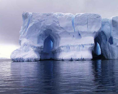
Ice sheets are defined as any mass of land ice with a surface area in excess of 50 000 square kilometres, larger than the country of Costa Rica. There are only two ice sheets currently existing, those being the Antarctic and Greenland Ice Sheets.


During the last glacial or ice age, several other ice sheets covered many of major continents. The period of time when these ice sheets were at their largest is also referred to as the Last Glacial Maximum (LGM). Canada and North America were under the Laurentide, Weichselian occupied most of Northen Europe and the southern end of the South American Continent was overlaid with the Patagonian ice sheet. They have since receded and disappeared, as the last glacial age peaked approximately 20 000 years ago.
That ice sheets once covered such an extensive range is known because of the characteristic deformation of the land beneath them – jagged and rugged gouges.

The two ice sheets are immense in size and quantity. If the Greenland ice sheet were to completely melt, the sea level would rise around six metres. If the Antarctic did the same, a rise of sixty metres is estimated. Antarctica alone holds approximately ninety percent of the world’s ice and eighty percent of its total fresh water.

These landforms occur when snow falls in areas cold enough that it does not entirely melt over summer. This snow solidifies further into sheets of ice and accumulates over thousands of years, the weight of fresh layers compressing older and causing them to become even more dense and thick. Their weight is such that if the Antarctic ice sheet melted, the rock beneath would rise over a kilometre and archipelagos would surface around it.

Ice sheets are subject to the irresistible pull of gravity, the cause of all erosion. Flowing down over land out to sea, they give rise to a number of other features such as ice shelves and glaciers which erode the environment that they themselves occur in.

When snow melts faster then the rate of replenishing, ice sheets will recede and melt. It is believed that the Greenland ice sheet is undergoing recession, while the Antarctic ice sheet is relatively stable. This recession has been used as proof of climate change and global warming, issues at the forefront of problems confronting humanity today.

Saturday 5 March 2011

Glaciers


A glacier is a large body of ice. Glaciers transport materials such as rocks and carves the land beneath them. They move by the heavy weight and the downward slope. A glacier’s weight combined with gradual movement can drastically change the landscape. Over many years, glaciers have changed the earth’s surface into something totally different. The ice erodes the land surface and carries broken rocks.
There are a few types of glaciers such as:
  • Alpine glaciers - they form the crests and slopes of the mountain and are also known as ' mountain glaciers', 'niche glaciers' or 'cirque glaciers.
  • Valley glacier - this is an Alphine glacier that fills a valley
  • Ice cap - also known as an ice field, these are large blocks of ice that can cover an entire mountain
  • Continental glaciers - even larger than an ice cap, it can cover over 50, 000 km squared
Glaciers form where the accumilation of snow and ice exceeds albation. As the snow and ice layer up, at a certain point the snow and ice start to move, forming a glacier.
The location where the glacier starts is called the glacier head. The glacier stops at the 'glacier foot' or 'terminus'.

Tuesday 1 March 2011

U-shaped Valleys

U-shaped valley
U-shaped valleys are formed after a glacier passes through a V-shaped valley. They are U-shaped with steep, straight sides and a flat bottom.  The U-shaped valleys occur when a glacier travels across a down slope, carving the valley by the action of scouring. The glacial erosion called glaciation and abrasion, which results in large rocky material being carried in the glacier. A material called boulder clay is deposited onto the floor of the valley. As the ice melt the valley is left with ver steep sides and a wide, flat floor. A river or stream may flow through the valley from the melted ice.
On the sides of an U-shaped valley, they may have hanging valleys. Hanging valleys are side valleys (valleys on the side) that are on the high, left side of a main valley that has been turned into a U-shaped valley.Streams that are in a U-shaped valley may form a waterfall as water can flow down the steepened sides. The valley may also have trunctated spurs. Trunctated spurs are the ends of sloping ridges cut (or truncated) by the valley glacier to flow straighter than a river.

Seracs


Seracs are blocks or columns of ice formed by intersecting crevasses on a glacier. They are often house-sized or larger, they are dangerous to mountaineers as they can topple at any second, which can result in serious damage or even death.
They usually look like a tall column of ice, which may have a pointed peak. They may stay up for a long time or it may collapse, depending on the weather conditions an altitude.
Seracs are found within an icefall, often in large numbers or on ice faces on the lower edge of a hanging glacier.
The word 'serac' comes from a Swiss name for a very dense, crumbly white cheese and from a distance, seracs can resembles giant blocks of cheese - at least to the imaginative eye.

Objective


Erosion is one of the major forces changing the surface of the Earth constantly. These alterations may be subtle, and they may be drastic. Regardless of which, erosion affects human society in more ways than one, and understanding this will bring to light benefits effected by this force. The landforms which give the Earth such character are all products of erosion.
This blog is a joint project aiming to detail the features and characteristics of the agent of erosion assigned to us: Ice.